La Palma, Canary Islands, Volcanic Eruption
Major incident created 1700 hrs 19th September 2021
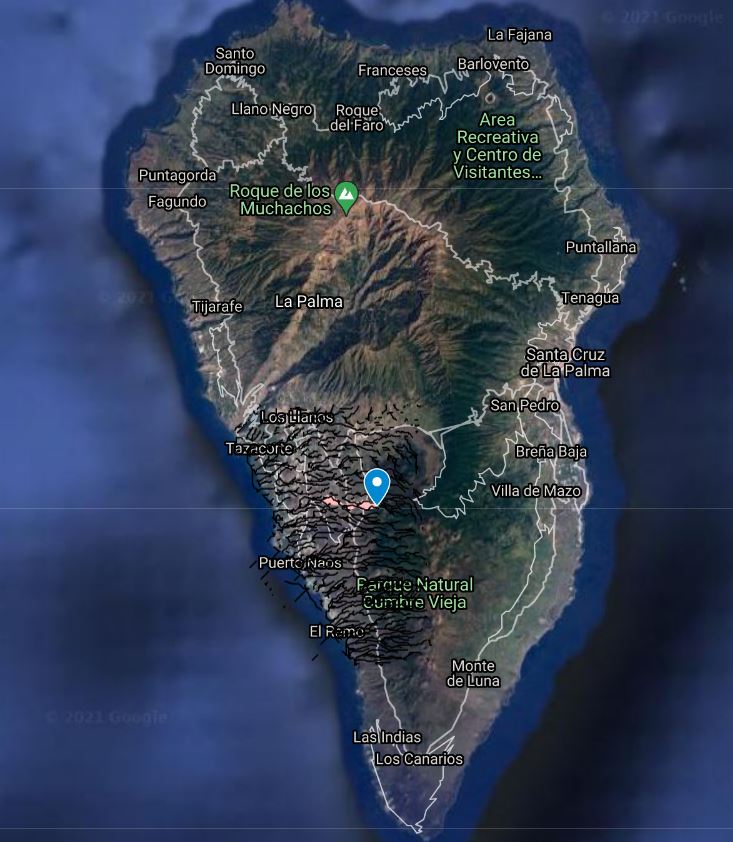
Teneguía volcano in La Palma in Spain’s Canary Islands erupted on Sunday 19th September 2021 at 3.15pm in the Montaña Rajada mountains in the municipality of El Paso.

KEY DATA:
Evacuations: At least 6000 +
Injuries: None serious reported
Deaths: Nil
Property damaged/destroyed: Copernicus, 1186 destroyed plus 95 damaged
Area affected: Devastated about 497 hectares of land plus 5576 affected
Infrastructure: 38.3 kms destroyed plus 3.1 kms damaged
Travel advice: FCDO Travel advice
The Foreign, Commonwealth and Development Office (FCDO) is not advising against people travelling to the Canary Islands.
A statement on its website says: “On Sunday 19 September 2021, at approximately 15.15 local time, there was a volcanic eruption on the Spanish Canary Island of La Palma. The immediate area of Cabeza de Vaca, El Paso has been evacuated.
“If you are in an affected area you should follow the advice of local authorities, including social media updates from Cabildo de La Palma. If you are planning to travel to the island imminently you are encouraged to contact your tour operators/airlines.”
Useful sources:
Global Disaster Alert and Co-ordination Centre for information concerning the current status of the incident villages affected etc
Consular Emergency Office, through the numbers +351 217 929 714 or +351 961 706 472, or the Honorary Consul of Portugal in Tenerife, through the mail email tenerife@consuladoportugal.es or telephone +(34) 665 893 825”.
This is how the beginning of the eruption of the Old Summit sounded: this is the sound of the seismic signal registered by the PPMA seismic station of the Canaria Seismic Network in La Palma between 13 and 16 (Canary Time) today September 19, 2021.
 Earthquakes are heard at the beginning that then make way to a continuous tremor generated by eruptive activity.
https://www.facebook.com/INVOLCAN/videos/888301875439020
UPDATE 1100 HRS SUNDAY 10TH OCTOBER 2021
Latest Damage report
Of the 1,281 infrastructures damaged by lava, 1,186 have been destroyed and 95 have suffered damage; while there are 497 hectares of destroyed land and another 5,576 hectares have been damaged. Regarding roads, 38.3 kilometres of roads are destroyed and another 3.1 kilometres that could be damaged.
Latest News
A new lava river of the Cumbre Vieja volcano on the island of La Palma is dragging stone blocks the size of a three-story building, warned today the Spanish Geological and Mining Institute (IGME).
 The IGME released a video recorded on the ground by its scientists in La Palma very close to the new flow, which shows the force with which it descends and the size of the blocks it drags, “equivalent to a three-story house”, reported the Spanish agency EFE . https://youtu.be/HwDgVuUzo3Q
The new river of lava was caused by the collapse, on Saturday, of the northern flank of the volcano on that island in the Canary Islands, located west of the coast of Morocco.
The Volcanes de Canarias association, a group of geologists and volcanology enthusiasts who collaborate with authorities on training programs for the public, warned that the volcano went through a phase with “highly noisy, energetic and sustained” explosions this morning, which provoked “ground vibrations” within a radius of up to six kilometers from the eruptive cone.
The Spanish National Geographic Institute (IGN) has announced that 21 earthquakes have occurred in La Palma in the last few hours.
The strongest recorded a magnitude of 3.8 and occurred at a depth of 34 kilometers in the municipality of Mazo.
The stream located south of the cone of the ‘Cumbre Vieja’ volcano, on the island of La Palma, located close to the main stream, is the one that currently worries experts the most as it is an important mass of lava. This is reflected in the latest report from the Department of National Security published at 08:00 this Sunday with data from the Government of the Canary Islands and the National Geographic Institute, in which it is recalled that yesterday Saturday the north flank collapsed after registering In the early hours of Friday a partial rupture of the wall of the cone, which has caused the exit of large blocks of material and the appearance of new flows.
 Shortly after reporting the cone’s collapse, scientists from the Volcanological Institute of the Canary Islands (Involcan) released a video showing a huge lava front surrounding the Camino de la Gata industrial park in Los Llanos de Aridane, the municipality most populous on the island. Thirty drones allow volcanologists to monitor the eruption from the air. Through these devices they carry out scientific, security and ocular flights.
Photo Members of the Emergency Military Unit collect lava samples from the volcano on La Palma.
UPDATE 1400 HRS TUESDAY 5TH OCTOBER 2021
The eruption continues without significant changes this morning, with lava fountain at the main vent; ash rising a 2-3 km and slowly drifting southwest, as well as a new lava flow from the now breached crater.
Already now, with only little more than two weeks of activity, it is significantly bigger than the two previous eruptions on the island during the past 100 years. The volume of erupted lava was estimated at 80 million cubic meters last Friday, and now probably more in the range of 100-120 million m3, surpasses both the eruptions of San Juan (1949, with 55 million m3 lava) and Teneguia (1971, 43 million m3 lava).
According to the latest data, the lava flows have covered more than 400 hectares of land, including 31 km of roads and destroyed more than 1000 buildings. The lava flows reach a maximum width of 1250 meters, and have a height of 8-50 meters. The slowly growing sea delta forms a peninsula about 40 hectares, and adds to the southwestern coastal western plains formed by recent volcanic eruptions.
Earthquakes continue to occur and have been slowly increasing in numbers and magnitudes approaching magnitudes of 4.0 now. During the past 24 hours, there have been 31 quakes of magnitudes 3.0-3.9 and 47 quakes between 2.0 and 2.9, while smaller quakes cannot be detected due to the volcanic tremor noise.
Since the beginning of the eruption at Cumbre Vieja (La Palma), the Volcanological Institute of Canary Islands (INVOLCAN) has been assessing the emission of sulphur dioxide (SO2) by this eruptive process underway. The amount of sulphur dioxide (SO2) accumulated from September 19 to October 4 has been estimated at 250.000 tons.
The plume has been hovering around the Canary Islands, North Africa, the Mediterranean, parts of it drifted over the Atlantic, even reaching the Caribbean to the west and the Arctic in the north.
UPDATE 1400 HRS SUNDAY 3RD OCTOBER 2021
The eruption continues and the lava output rate remains very high and volcanic tremor is stable at high levels.
The new lava flow from the separated vents just below the north western base of the erupting cone slowly make their way through so-far untouched land north of the existing flow field, destroying additional buildings and other infrastructure so far spared. The flow forms an impressive channel of approx. 50 m width and there is no explosive activity at its vent. Video from last night
https://twitter.com/i/status/1444567982110281728
At the cone itself, approx. 8 vents in total are active producing several lava flows, some of which seem to go directly into lava tubes, others overlapping older flows or feeding more or less stable lava channels. Some of the lava still finds its way to the sea entry, which is growing slowly.
The upper vents produce tall pulsating lava fountains, with moderate ash plumes. When observed yesterday evening, the lower vent on the NW flank of the cone, which had been a site of near-constant low, liquid fountaining gradually ceased to produce fountains, but it seems that the energy then went to the NW summit vent, which started an impressive show of violent, near vertical fountaining reaching 3-500 m height:
Since 15:00 p.m. (Canary Time) October 2, 2021, the Canary Seismic Network on the island of La Palma records a rebound in the extent of the volcanic tremor related to an increase in Strombolian type explosive activity.
Authorities advised people to limit time outdoors in parts of La Palma on Saturday as the erupting volcano on the Spanish island spewed red-hot lava and thick clouds of black smoke.
The Portuguese Institute of the Sea and Atmosphere (IPMA) confirmed yesterday that some of the particles emitted by the volcano of Cumbre Vieja, in La Palma, will have reached the Azores, causing a “significant reduction in horizontal visibility”.
In a statement, the IPMA reveals that following the eruption of that volcano, since September 19, “gases and particles have been emitted into the atmosphere” that “are transported over long distances”.
Informative Update: Since September 10, 2021, the Canary Seismic Network has detected on the island of La Palma almost 30.000 earthquakes, of which 1950, have been able to be located. The maximum magnitude recorded, to date has been 4.2. In the past 24 hours and 78 earthquakes have been located with maximum magnitude of 3.3. Source Instituto Volcanológico de Canarias
UPDATE 1700 HRS
The lava from the Cumbre Vieja volcano in La Palma, which fell into the sea, already covers an area of more than 20 hectares, according to an estimate made by the European Space Agency.
Based on an image from the European Copernicus satellite system taken on Wednesday, the lava emitted by the volcano since the beginning of its eruption on September 19 covers 709 hectares, including the surface that has been reclaimed from the sea since the night of the day. September 28, and hit 1,005 buildings, of which 870 were destroyed.
The number of kilometers of affected roads also increased to 30.2 km, of which 27.7 km were destroyed by lava flow.
The volcano has emitted 80 million cubic meters of material since it began its eruption, said the president of the Spanish region of the Canary Islands, Ángel Víctor Torres .
The lava flow emerging from the two new emitter centers of the Cumbre Vieja volcano in La Palma seeks to join the original lava flow as it moves towards the sea.
The technical director of the Spanish Volcanic Risk Prevention Plan, Miguel Ángel Morcuende , and the director of the National Geographic Institute in the Canary Islands, María José Blanco, explained today at a press conference that these two transmission centers, which opened in the early morning hours , are about 15 meters away and 600 meters from the main cone.
With these two new outlets, there are now four lava foci that emit in the volcano in La Palma , which, according to Morcuende , maintains an “intense” activity.
SITUATION REPORT FRIDAY 1200 HRS 1ST OCTOBER
Newly constructed lava delta continues to grow as hot lava flows entered the sea and are extending the coastline outwards.
Explosive activity continues. Volcanic Ash Advisory Center (VAAC) Toulouse warned about a volcanic ash plume that rose up to estimated 14000 ft (4300 m) altitude or flight level 140 and is moving at 10 kts in NW direction.

The eruption continues with stable lava output, feeding several lava flows both near the vent and the main one that is supplying lava to the new ocean entry, which continues to grow slowly.
During most of yesterday, southerly winds caused continuous ash fall in the area of El Paso and beyond, making driving etc difficult and the air filled with dust. At the vent, activity remains intense: vigorous lava fountaining with heights between estimated 50-100 m continued at the fissure vent on the NW lower flank, while several vents in the summit as well as two newly formed vents in between were producing pulsating, powerful and near-vertical jets of gas, ash and lava bombs.
 The vents are aligned along a northwest-southeast trending line, presumably reflecting the original eruptive fissure.
The cone itself is subject to frequent and sometimes dramatic changes. During the day, we observed increased steaming and dust rising from the northern flank of the cone complex and were speculating about new cracks opening as the cause resulting in movements of that flank.
Later in the evening, two new fissures opened on the NW flank and rapidly emitted two new lava flows that quickly descended parallel to the north of the existing flows, covering and burning additional land, probably including other so far untouched buildings in the evacuation zone.
The new eruptive fissures we observed are in the line of the other vents and below the main lava fountaining vent.T
SITUATION REPORT THURSDAY 30TH SEPTEMBER
The Cumbre Vieja volcano in La Palma, in Spain’s Canary Islands, on Thursday increased its eruptive force and was emitting a greater quantity of ash than when its lava reached the sea on Tuesday night, sources from the National Geographic Institute (IGN) confirmed. They warned that explosions are now being registered in the north slope of the main cinder cone. This new situation could cause the cone to collapse in the short term, something that is within the forecasts of the volcanologists who are working on the island.

The team of experts monitoring the phenomenon, the Volcano Risk Prevention Plan (Pevolca), has not seen evidence that the “dynamic of the eruption process is at all stable,” as they warned yesterday. For this reason, sea and land exclusion zones remained in place on Thursday, as did the evacuation of residents and the lockdown in the areas of San Borondón, Marina Alta, Marina Baja and La Condesa.
“We are carrying out studies and monitoring constantly and until we know which areas are out of risk, these measures will remain in place,” explained the technical director of Pevolca, Rubén Fernández. It was still unclear on Thursday how dangerous the gases were that have been emanating from the sea since the lava met the ocean. The IGN stated that the reach of the gases was limited to the area where the molten rock met the ocean.
Meanwhile, the eruption continued to increase the surface area of the island on Thursday. The outfall of the lava on what used to be Guirre beach now measures 17.2 hectares, meaning that it has grown three times compared to the official data released at midday on Tuesday.
Newly constructed lava delta continues to grow as hot lava flows entered the sea and are extending the coastline outwards.

SITUATION REPORT WEDNESDAY 29TH SEPTEMBER 2021
The molten rock has reached 744 buildings on the Canary Island so far, 656 of which have been completely destroyed
 By Wednesday afternoon, the lava had already covered between five and 10 hectares of the sea, according to calculations by EL PAÍS. It measured 500 meters wide, and had changed the colour of the water surrounding it, according to Ramón Margalef Eugenio Fraile, from the Spanish Oceanographic Institute (IEO), and who was speaking to Spanish news agency EFE. The lava was spreading bit by bit, and by this morning already measured around 50 meters high, forming a kind of pyramid.
Video of it entering sea https://www.facebook.com/INVOLCAN/videos/573170663802024
By Wednesday, the lava had reached 744 buildings on La Palma, 656 of which have been completely destroyed, and it had covered an area of 267.5 hectares. Meanwhile, 23.1 kms of roads had been affected by the molten rock, 21.5 kms of which had also been destroyed, according to the latest information from the European satellite system Copernicus. On Wednesday there were major concerns about the connecting roads in the south of La Palma, such as those serving Puerto Naos and La Bombilla.
The lava flow remains active, and has already constructed a sizeable new lava delta reaching out perhaps a few 100 m into the sea. At the active cone, the lower vent continues to produce a lava fountain and feed the main lava flow.
The vents at the summit were seen generating dense ash columns drifting east towards the ocean. Here are some impressions of how the scene looked at around 1 p.m. today.
Upon reaching the ocean, the lava from the volcano on the Spanish island of La Palma has generated a column of water vapour and possibly toxic gases, circumscribed to the contact zone of the magma and the sea and without affecting the population, and has created a delta about half a kilometre wide.
Experts insist that, outside the 2.5-kilometer security perimeter, security is guaranteed to “run smoothly”, except for “discomfort”
 The central government has announced that it will be acquiring 107 properties “before the end of the year,” to allocate them to those who have lost their homes.
UPDATE 28TH SEPTEMBER 2021 1800 HRS
This map today shows the progression of the lava flow (Copernicus)

589 buildings destroyed (+76 compared to Monday)
The lava flow covers 258 ha
21 km of roads destroyed
No significant changes have occurred during the past hours. Tremor is at moderately high levels and more or less stable. An eruption column is rising from the vent, producing a plume rising to 5-6 km altitude.
New satellite images of an active volcano on the Spanish island of La Palma capture vivid streams of lava pouring down the coastal mountain range and nearing the Atlantic Ocean.

Bright streaks of lava flow through populated parts of the Spanish island of La Palma on Sept. 26, 2021. (Image credit: NASA Earth Observatory images by Lauren Dauphin, using Landsat data from the U.S. Geological Survey)
The Landsat 8 satellite images offer a natural-colour view of lava streaming through the communities of El Paraiso and Todoque, along with clouds of white smoke rising from the area. The hot, molten lava spewing from the eruption glows red in the satellite imagery, while a dark, black crust appears in areas where the lava has cooled at the surface.
The satellite observations from Sept. 26 also captured infrared views of the volcanic eruptions, revealing the hottest parts of the red hot lava flowing down the slopes of the crater.
Explosive activity continues. Volcanic Ash Advisory Centre (VAAC) Toulouse warned this afternoon about a volcanic ash plume that rose up to estimated 20000 ft (6100 m) altitude or flight level 200 and is moving at 15 kts in SE direction.
https://www.space.com/la-palma-volcanic-eruption-landsat-8-photos
UPDATE 20.00 HRS
MONDAY 20.00 HRS 27TH SEPTEMBER 2021
The volcano on Spain’s La Palma island began ejecting lava again on Monday after a lull, while hundreds of people in coastal villages hunkered down in anticipation of lava emitted in previous days reaching the sea and releasing toxic gas.
 According to Volcano Discovery activity is picking up again. The volcano has been producing intermittent explosions with ash emissions from the new cone, at intervals of roughly every 10 minutes.
To put the eruption into perspective, the newly lava-covered surface of 221 hectares (2,21 sq km) corresponds to 0,3 percent of the island’s total surface of 708 sq km.
 It is interesting to look at the volume of lava erupted so far: if an average thickness of the lava flows of 10 m is assumed and the total surface covered is 212 hectares (=100×100=10,000 sq meters), the volume is approx. 10×2,120,000 or roughly 20 million cubic meters.
This does not include the volume of the cone and the erupted ash, but likely the latter are much smaller than the volume of the lava flows and can be neglected. In any case, the volume of erupted material is in the same order of size as the previously modeled magma volume estimate that had been intruded during the earthquake swarm (also around 20 or more million cubic meters).
If these figures are correct (which is far from certain), the eruption indeed might have exhausted the available magma, but the near future will certainly tell.
Video of the activity at 80m Canary Islands time
UPDATE 1500 HRS SUNDAY 26TH SEPTEMBER 2021
The eruption continues at fluctuating intensity and with significant changes at the morphology of the new crater:
During the course of yesterday, a significant portion of the western flank of the cone collapsed, likely during a series of rockfalls, leaving a narrow horse-show shaped breach, thus lowering the main vent, which continued to produce violent pulsating lava fountains at fluctuating intensity.

Photo: Lava fountain from the main vent at Cumbre Vieja last night; the collapsed crater area can be seen clearly if compared to similar photos from earlier updates (image: Tom Pfeiffer / VolcanoDiscovery)
During periods, the jets of lava likely surpassed 500 m in height with individual bombs reaching perhaps up to around 1000 m in height. Jets usually were more or less vertical, but sometimes also oblique to the west, suggesting the presence of at least two closely-spaced vents.
The lava flow from the effusive vent on the NW flank of the cone seemed to almost cease during the evening, but later resumed, creating a new flow in the same channel. This lava flow was still active by the time we left the scene at around 10 a.m.
Violent spattering could be seen at the vent; the following video shows the high fluidity of the erupted lava:
Fluctuating intensity of lava fountains
The lava fountaining activity from the main vent changed somewhat as it became more fluctuating after late last night, switching from moderate to very intense during phases lasting several minutes.
After around 0.30 a.m. local time this morning, the fountains significantly decreased and switched to intermittent, weaker pulses.
Later, they resumed and gained strength again, but decreased again in the early morning hours, only to pick up again a bit.
The associated ash plume was weaker than during the previous days, but still rose to approx. 3 km height and slowly drifted towards north easterly directions.
In undisturbed areas around El Paso and Tacande, there is now a 3 cm thick deposit of black ash and lapilli from the ongoing eruption.
Seismic and deformation data
Tremor intensity remains high, but with significant fluctuations over periods of hours. Overall, its trend is either to be stable or even increasing. The latest GPS data suggest that ground deformation is slowing down and coming to a halt, suggesting that the overall magma effusion rate is now in balance with the supply of magma into the shallow reservoir feeding the eruption.
As to what might happen next, there can only be speculation at this point.
The speed of progress has been uneven during the week. The lava covered 150 hectares in the first 42 hours (3 per hour), then advanced only 10 in the next 36 hours (0.3 per hour). On Thursday the pace increased again, gaining 26 hectares in 25 hours (1 per hour). But from Thursday to Saturday morning, moment of the last image, the advance has been 20 hectares in 36 hours (0.5 per hour).

The wash has already engulfed about 570 buildings, according to the latest satellite image on Thursday. According to the cadastre, the majority are houses, garages and other residential constructions, although there are also 70 buildings for industrial, commercial or agricultural use.
Another 1,650 are intact but at risk, most in the direction of the sea. They are the buildings that are on the possible trajectories of the lava languages, according to the probabilistic predictions of the University of La Laguna.

UPDATE 2100 HRS
Informative update: in the last hours the magnitude of the volcanic earthquake has dropped significantly in all stations of the Canaria Seismic Network in La Palma. We remember that the volcanic tremor is related to the intensity of the Strombolian explosive activity that has characterized almost all of the historical eruptions in the Canary Islands.

Earlier today volcanic explosions had spewed red hot lava high into the air on La Palma on Saturday as a new emission vent opened, forcing the small Spanish island to close its airport and causing long queues for boats off the island.
The Cumbre Vieja volcano, which began erupting last Sunday, is entering a new explosive phase. The Canary Islands Volcanology Institute, Involcan, said the new emission vent that had opened was to the west of the principle vent.
The national Geographical and Mining Institute said its drones had shown the volcano’s cone had broken.
“It is not unusual in this type of eruption that the cone of the volcano fractures. A crater is formed that does not support its own weight and … the cone breaks,” Miguel Angel Morcuende, director of volcano response committee Pevolca, told a news conference on Saturday. “This partial rupture happened overnight.”
UPDATE 1200 HRS
Flights to and from the Spanish island of La Palma are cancelled Saturday 25th September 2021 because of an ash cloud spewing out of a volcano that has been erupting for a week.
 La Palma Airport operator Aena said on Twitter that plane traffic was suspended “due to the accumulation of ash” in the air.
AENA [Spanish Airports and Air Navigation] reported that the other airports in the Canary Islands are operational, although it recommends that travellers check the status of their flights with their airlines.
“The priority is to guarantee the safety of operations,” said the head of La Palma airport.
In addition, ENAIRE, air navigation manager in Spain, has established two restricted areas of airspace in the municipalities of El Paso and Los Llanos de Aridane, temporarily until the end of the emergency, in the land and sea area below 3,000 feet, which can only be entered by State security forces and bodies, emergency services, State aircraft and those duly authorized, which does not affect commercial aviation, which does not fly over these two restricted areas.
Flight schedules show all arrival and departure flights cancelled.
UPDATE 0900 HRS SATURDAY 25TH SEPTEMBER 2021
The eruptive process of the Cumbre Vieja volcano during yesterday afternoon, resulted in the implementation of the evacuation plan which is part of the Special Plan for Civil Protection and Attention to Emergencies due to Volcanic Risk of the Canary Islands (PEVOLCA) for the areas of Tajuya, Tacande de Abajo and the area so far not evacuated of Tacande de Arriba, in the municipality of Los Llanos de Aridane.
In total, some 160 people have been evacuated, most of whom spent last night in the homes of relatives or friends by their own decision, 12 at the Teneguía Princess hotel, in Fuencaliente, and another 10 with mobility problems who were accommodated in the Quartering. Since the eruption began last Sunday, an estimated 6,000 people have been evacuated.
The director of the National Geological Institute (IGN) in the Canary Islands, María José Blanco, explained that around 1:00 p.m. the largest seismic signal had been recorded so far in the main cone of Cumbre Vieja.
As a result it was decided to advise the confinement of the population to protect them from the emission of volcanic particles, closing doors and windows, and recommending that people stay away from windows due to the possible breakage of glass due to pressure waves.
The Steering Committee held on Friday was attended by the President of the Government of Spain, Pedro Sánchez, who highlighted the magnificent collaboration and coordination of all administrations to solve the immediate and future problems of the population and relaunch La Palma after the volcanic eruption.
Sánchez, who was accompanied by the president of the Canary Islands, Ángel Víctor Torres, the Security Councilor and director of PEVOLCA, Julio Pérez, and the president of the Island Council, Mariano Hernández Zapata, highlighted that an example of unity is being shown in this emergency of all the administrations that must tackle the reconstruction of the Island.
The administrations have launched the necessary initiatives to face the housing emergency of families who have lost their homes. It is estimated that there could be some 400 damaged or partially damaged buildings / infrastructures within the perimeter of the flows. This figure includes homes, tool rooms, swimming pools or reservoirs, as well as other facilities yet to be defined.
The teams involved in the operation amount to almost 800 security and emergency personnel from different institutions of the Town Halls, Island Councils, the Government of the Canary Islands and the Government of Spain, in addition to volunteering.
The perimeter of exclusion by sea is maintained, from the south by Punta del Pozo (Puerto Naos), to the north by Las Viñas beach (Tazacorte), and parallel to the coast, two nautical miles from the coast, established by Maritime Captaincy.
In addition, ENAIRE, air navigation manager in Spain, has established two restricted areas of airspace in the municipalities of El Paso and Los Llanos de Aridane, temporarily until the end of the emergency, in the land and sea area below 3,000 feet, which can only be entered by State security forces and bodies, emergency services, State aircraft and those duly authorized, which does not affect commercial aviation, which does not fly over these two restricted areas.
UPDATE 20.00 HRS
Infrared video sequence of the current activity and the lava leaks coming from the two new eruptive mouths.

UPDATE 1600 HRS
 In the last hour it was reported that explosive activity in the Old Summit has intensified in the last hours. In this video you can see (and hear) a shock wave generated by a powerful Strombolian explosion. Video shows here:
https://www.facebook.com/INVOLCAN/posts/307251057872557
The Cumbre Vieja volcano on the island of La Palma (Canary Islands) remains active, with more explosive periods and having already devastated about 240 hectares of land in a perimeter of about 16 kilometres.
Data also provided today by the Spanish Department of National Security (DSN) show that the column of gases coming out of the volcano reaches up to 4,500 meters in height.
Two lava flows remain active: the northernmost one is almost stationary and has a maximum height of 12 meters, while the southern front continues to advance at four to five kilometres per hour with a height of 10 meters.
The lava flow is 3,800 meters long and is 2,100 meters off shore.
The lava had also destroyed 390 buildings (40 more than the day before) and 14 kilometres of roads.
The civil protection service of the Canary Islands insists that “the sulphur dioxide values indicate that the air quality is good and that acid rain is excluded”.
The DSN report adds that on Thursday the action of the wind at the surface caused air displacements that caused some delays in the departures or arrivals of some flights between Tenerife (the largest of the islands in the archipelago) and La Palma.
The organization that manages airspace in Spain (Enaire) recalled a few hours ago on its social networks that “the airspace of the Canary Islands is operating normally”.
On the other hand, the perimeter at sea is maintained, established by the maritime captaincy up to 2 miles from the coast, between Puerto Naos and Tazacorte, two municipalities on the island of La Palma.
The regional government of the Canary Islands is holding an extraordinary meeting today, with the presence of the Spanish Prime Minister, Pedro Sánchez, at which it plans to approve aid to people affected by the situation.
UPDATE 24TH SEPTEMBER 2021 0800 HRS
The following lava flow map has just been released

UPDATE 17.00 HRS
The eruption has been becoming “ashier”; today, the plume has been reaching 4000 m and is visible from much of the island.
 Deformation data show inflation overall is continuing although the trend has slowed down, or even decreased temporarily yesterday. Volcanic tremor remains high, but has been showing a slight decrease compared to the past days.
This suggests that the eruption might be becoming more stable, although it cannot be ruled out that new fissures open and new lava flows might appear.
This is a video of the eruption earlier 23rd September
https://www.facebook.com/INVOLCAN/videos/3428067810651765
UPDATE: 0800 HRS THURSDAY 23RD SEPTEMBER 2021
A new lava flow map of the current eruption site has been published and updated today.
The map depicts current lava flows that continue to keep active and slowly advancing towards the coast.
The aerosol plumes from the eruptions continue to travel along the northern Africa and south Europe. A GIF animation depicts the volcano’s SO2 emissions traveling around the northern Africa and southern Europe (source: @m_parrington/twitter) 
The Copernicus’s latest satellite-based measurements of SO2 concentrations in the atmosphere depict that they will reach Morocco, Tunisia, Algeria, Libya including a large part of Iberian Peninsula and Mediterranean coasts of France and Italy this Friday (24 September).
According to Windy.com’s visualization, the highest level of sulphur dioxide (SO2) emissions will likely occur in these areas. https://twitter.com/i/status/1440608903289397251
Activity continued to increase overall. During the course of the morning, two more fissures opened, one close to the original ones and another one further north of the existing vents, southeast of Tacande village, which was evacuated soon after. The opening of the vent followed rapid ground inflation in this area of 15 cm, according to unconfirmed information.
 Most activity now seems to occur from the Tacande vent. It is well visible from the highway LP3 when going west after exiting the tunnel and attracts many tourists and locals alike to watch. Already, an elongated cinder cone has formed around it, and continuous lava fountains have been rising to approx. 2-300 m or more in height, producing a steam and ash plume that was rising approx. 2000 m and visible when we approached the island by airplane.
Our local correspondents who helped in recovery operations to save household items from threatened homes down from the active lava flow fronts, reported heavy ash fall in the downwind areas to the SW.
The lava flow fronts, often exceeding 10 m in height, slowed down further today but continue to widen; the largest one remains in the centre of Todoque where more houses have fallen victim to the lava.
In total, the eruption has destroyed more than 320 homes and covered over 140 hectares of land by lava flows so far.
UPDATE 20.00 HRS
A Portuguese citizen residing on the island of La Palma, in the Canary Islands, Spain, had to leave her home due to the trajectory of the lava flow from the Cumbre Vieja volcano which, last Sunday, erupted. There are now 12 Portuguese identified on that island.
The information was revealed by the Secretary of State for Communities, Berta Nunes, in statements to RTP. “We found two more Portuguese and we have information that a Portuguese woman whose house was on the lava path has already had to be removed ,” the official told the public station, adding that it was the woman herself who “left [her] house and went to house of a family member”.
National citizens who are in La Palma “have communicated that they are fine”, Berta Nunes also assured, stressing that they “have become more secure because they know they can ask for help at any time”.
 The volcanic eruption in La Palma, in the Canaries, is emitting a high amount of sulphur dioxide into the atmosphere, which is expected to reach, this Friday, much of the territory of Spain, as well as the Mediterranean coast.
UPDATE 0800 HRS WEDNESDAY 22ND SEPTEMBER 2021
Last night, activity noticeably increased from the second vent that had opened the day before and quickly became the main one.

Lava fountains of several hundred meters height as well as large exploding lava bubbles were observed. The noise level of the eruption also increased.
Impressive lava fountains continue to shoot into the sky from the four eruptive fissures feeding lava flowing slowly towards the coast.
Several lava flows form a spreading field of lava which has currently covered 1.54 square km by 21 September.

185 buildings have been already destroyed and more than 5,700 persons evacuated.
 Miguel Albuquerque (President of the Madeira Regional Government) sent a letter to Ángel Víctor Torres (his Canary Islands counterpart) to express his and his Government’s full solidarity in the wake of the La Palma volcanic eruption.
He also offered to send whatever assistance is needed. Several Civil Protection teams have been made available for deployment. These include a Mountain Search and Rescue brigade, paramedic teams (including doctors and nurses), and a helicopter carrying a multi-mission team.
How long could the current volcanic eruption last at Old Summit?
According to Instituto Volcanológico de Canarias’s posted this morning “it’s a very assiduous question we’ve been asked since the current volcanic eruption started at Old Summit. Using the data we know about the duration of historic eruptions that occurred in La Palma Island, you could get a possible answer to this question not easy to answer. Therefore, it would be acceptable to convey that we move in the range of a duration between 24 and 84 days, with a geometric average of the order of the 55 days long”.
UPDATE 22.00 HRS
The Canaria Seismic Network reported around 3 hours ago, “that it is recording in the last 4 hours a strong increase in the magnitude of the volcanic tremor in the Old Summit, which is an indicator of the intensity of the Strombolian explosive activity in the active mouths at the moment”. In the figure below, the red line marks the beginning of this eruption.

Source https://www.facebook.com/INVOLCAN
The latest eruption took place about 3 hours ago captured on this video https://twitter.com/i/broadcasts/1BRJjBgZQRdJw
Pedro Sanchez, the Spanish Prime Minister, said it will be “weeks” until all of the damage is properly assessed, as steps were taken to declare a state of emergency in the region.
“Today, in the cabinet meeting, the government began all the steps to activate the procedure to declare the state of emergency in the region by the government, these will be long weeks so that we can assess all the damage,” he told journalists at a press conference.
“The management of the crisis will not end when the lava meets the sea, but rather when La Palma regains its normality and we have agreed to rebuild everything that has been destroyed already by the lava.”
The new vent opened after what the Canary Islands Volcanology Institute said was a 3.8-magnitude quake late on Monday.
UPDATE 1900HRS
The eruption continues with lava fountains from the new vent that opened last night and continuing lava flow emission. During the past hours, volcanic tremor has increased significantly, suggesting that output rate has increased or something else is changing. It will probably become clearer in the next hours what is happening.
During the past 24 hours, activity has been relatively stable. The advance of the fronts have slowed down and they remained at approx. 1 km from the shore, due to the fact that the flow fronts are now in less steep terrain, which causes them to widen significantly as well rather than progress. However, they are now slowly advancing through the town of Todoque, destroying it.
The 1,200 residents from Todoque had no choice than to gather as much of their belongings and now can only watch as houses, streets, gardens are covered meter by meter by the advancing lava flows.
There are concerns that the eruption is still far from stable and yet more vents, possibly further north could open up. Inflation has been continuing and reached 30 cm in places, sign that magma is still pressurizing and accumulating underground. This is is also shown by continuing earthquake activity. Although much weaker than before the eruption, it remains significant. During the past 24 hours, there were 3 quakes of magnitudes 3.0-3.8 and 12 quakes between 2.0 and 2.9.
Another concern is the development of acid steam clouds should the lava flows enter the sea, and cause violent water-lava explosions that generate hot steam plumes mixed with hydrochloric acid (HCl) and other dangerous gasses that can be harmful to people, animals and plants.
UPDATE 1200 HRS
In the last hours, the lava flows have been approaching the urban centers of Todoque town, part of Los Llanos de Aridane, located southwest of area known as Isla Bonita. Authorities have closed the roads LP-211 Todoque, LP-212 Tacande, LP-213 Puerto Naos, LP-215 Tazacorte-La Laguna and LP-2 at the height of Tajuya, in addition to the La Cumbre highway, LP-3, which is subject to restrictions.

The above map shows the approximate extent of the lava flows as of this morning
This video shows very clearly how the lava id affecting areas in its path:
https://www.facebook.com/MeteoTrasOsMontes/videos/441081483992359
The eruption continues with no major changes over night. Fortunately, the advance of the active lava flows has decreased and not yet reached the sea it had been feared it might have done so by last evening.
This is giving valuable time to evacuate houses and other buildings in its path, for example the Ermita de San Pío X church complex in Todoque.
 Lava fountaining continues from the new vent that opened yesterday evening, and a cinder cone is already growing around it. The rate of deformation of the ground seems to slowly decrease, which might be a sign that the eruption is stabilizing. In addition, earthquake activity has decreased.
Explosive activity continues. Volcanic Ash Advisory Center (VAAC) Toulouse warned about a volcanic ash plume that rose up to estimated 8000 ft (2400 m) altitude or flight level 080 and is moving at 5 kts in SW direction.
Scientists thought that the lava flow would reach the coast at around 8pm on Monday night, local time (the Canary Islands, which are located off the north western coast of Africa, are one hour behind the rest of Spain). However, the advance of the rivers of molten rock slowed and this forecast was not met.
Miguel Ángel Morcuende, the technical chief of Pevolca, explained last night: “We have had less activity in the volcano, less volume of magma mass. The activity of the volcano is slowing. The lava flow is in the Todoque neighbourhood. It is still halfway to the sea. It is not going to arrive tonight.”
When the lava tongue, which has a temperature of around 1,000ºC, reaches the sea, which is little over 20ºC, experts say there will be an explosion of water steam that will create a dense white cloud. This plume is caused by the lava flow due to its extreme heat. But the molten rock will also trigger a chemical reaction, mainly of chlorine, which can irritate the skin, eyes and respiratory system.
According to the information made available in the Councils for Travelers published on the Portal of Communities, it is recommended that the Portuguese who are on the island of La Palma to follow the instructions of the local authorities and respect the safety lines established by the security and civil protection forces. It is also recommended that they are prepared for a possible evacuation”, specifies the statement.
The MAI also states that, “in case of need, national citizens may contact the Consular Emergency Office, through the numbers +351 217 929 714 or +351 961 706 472, or the Honorary Consul of Portugal in Tenerife, through the mail email tenerife@consuladoportugal.es or telephone +(34) 665 893 825”.
UPDATE TUESDAY 21ST SEPTEMBER 0800 HRS
According to information from the organizing Committee of the Plan for Volcanic Emergencies in the Canary Islands (PEVOLCA), a new mouth of the volcano appeared on Monday night, about 900 meters from the main one. There are plans to withdraw the population from that location, in the area of El Paso.
 This eruption, expels through two aligned cracks, from north to south and about 200 meters apart, with several emission points, as detailed by the scientific committee that monitors the occurrence.
According to the most recent information, the volcano now has a new eruptive mouth near the city of Tacande, which forced the evacuation of more houses.
Tacande is a city with 704 inhabitants, but authorities have not been able to specify how many will have to be evicted from their homes, warning that evacuations must follow precautionary criteria.
Last night, four earthquakes were recorded in La Palma, at least two were felt by the population, according to El Pais.
About 360 tourists were evacuated from a resort in La Palma following the eruption and taken to the nearby island of Tenerife by boat early on Monday, a spokesperson for ferry operator Fred Olsen said. A total of more than 500 tourists had to leave their hotels.
Anticipating reduced visibility, maritime authorities on Monday closed down shipping to the west of the island.
Around 100 homes have been affected by the volcano’s eruption, said regional emergency official Jorge Parra, adding that residents should not fear for their safety if they follow authorities’ recommendations.
Six roads on the island were closed, officials said.
Regional leader Angel Victor Torres said the damage would be substantial. “It is still active and will continue to be active for the next few days,” he added.
No fatalities or injuries have been reported but drone footage captured two tongues of black lava cutting a devastating swathe through the landscape as they advanced down the volcano’s western flank towards the sea.
The regional premier of the Canary Islands, Ángel Víctor Torres, also appeared at the press conference with Sánchez and Grande-Marlaska. He explained that the lava flow is likely to continue moving toward the sea over the course of Monday, and that the volcano had already emitted more than 20,000 tons of sulfur dioxide. A lack of windy weather meant that the activity at the airport on the island was able to continue without interruption on Monday.
Airspace around the Canaries has remained open with no visibility problems, the Enaire civil air authority said after a local airline cancelled four flights between islands.
Impact on Madeira
The ash from the volcano erupting in the Canary Islands (Spain) will hardly affect Madeira, at least in the next few days, given current weather forecasts, said today meteorologist Maria João Frade, from the Portuguese Weather Institute, IPMA.
“In terms of what is expected for the Madeira archipelago in the coming days, it will be very unlikely, it is not impossible, but it is very unlikely that the volcanic ash that is currently over the Canary Islands region will have an impact on the Madeira archipelago”, Maria João Frade from IPMA told press agency, Lusa.
UPDATE 22.00 HRS
Reuters) – Lava flowing from Spain’s Canary Islands’ first volcanic eruption in 50 years has forced the evacuation of 5,500 people and destroyed around 100 houses but the streams were advancing slower than originally predicted, authorities said on Monday.
The flow of molten rock will not reach the Atlantic Ocean on Monday evening as earlier estimated, an official said. Experts say that if and when it does, it could trigger more explosions and clouds of toxic gases.
“The movement of lava is much slower than it was initially. There has not been a large advance during the day,” local emergency coordinator Miguel Angel Morcuende told a press briefing on Monday evening. He said the stream had made its way about halfway to the coast.

Above photo taken last night just after moonrise by Alistair Hamil (Twitter) shows the closeness to inhabited areas on west flank of the island.
UPDATE 20.00 HRS
The lava flows continue to advance towards the coast. According to the latest forecasts, they might reach the sea shore by around 8 p.m. local time, most likely in the area of Playa Nueva in Los Guirres.
 Maritime authorities have already established an exclusion zone in the sea, stretching from Punta del Pozo (Puerto Naos) in the south to Las Viñas beach (Tazacorte) in the north, and half a nautical wide. On land, security forces are present to prevent unauthorized access.
Volcanic tremor as a measure of lava supply rate remains relatively stable and overall high. All suggests that the eruption is going to last for a while, possibly weeks or even months.
The SO2 plume from the eruption in the meantime is visible east of the island over the Atlantic ocean:
UPDATE 1600 HRS
There are at least eight Portuguese in the region affected by the volcano
The Secretary of State, Berta Nunes, stressed that that these eight Portuguese citizens reside in the three affected municipalities, but, for now, it is not known that they need any kind of help.
According to Berta Nunes, so far, it has not been communicated to the Portuguese authorities that these people needed any kind of help.
The official also said that there would be around 500 tourists on the island of Palma who are being removed from the territory, but, at the moment, there is still no information about the Portuguese among them. If there are possibly nationals among these tourists, Berta Nunes advises them to contact the consular emergency office by email or by phone (on the community portal).
In the entire island of Palma, the secretary of State concluded, there are about 60 Portuguese people, having assured Berta Nunes that the Government is in permanent contact with the local authorities, monitoring the development of the situation.
In an update made this Monday, the Portuguese meteorological service says that the wind from the northern quadrant will remain until Wednesday, “so the transport of CO2 and SO2 should not be significant”.
However, from that day onwards, “the wind is expected to rotate, which will pass to the south quadrant, so that changes in air quality may occur” , warns the IPMA.
UPDATE 1400 HRS
European Commission today activated, at the request of Spain, the Earth Observation Program of the European Union (Copernicus) to monitor the Cumbre Vieja volcano on the island of La Palma, which erupted in Las Manchas.
The information was provided by the president of the community executive, Ursula von der Leyen, who indicated that ” the EU [European Union] activated Copernicus to monitor the situation ” in La Palma, in an allusion to the program that is coordinated and managed by the European Commission and executed in partnership with Member States, the European Space Agency, the European Organization for the Exploitation of Meteorological Satellites, the European Center for Medium-Term Weather Forecasts and other European agencies.
Ursula von der Leyen said that Brussels is “in contact with the Spanish authorities to provide additional support if necessary”.
UPDATE 1300 HRS
The eruption in the Cabeza de Vaca area, in El Paso municipality, continues from at least 8 active vents along the two eruptive fissures that opened yesterday at about 200 m distance from each other. The lava has already entered the municipality of Los LLanos de Aridane when crossing the LP2 highway, and is directed towards the centers of La Bombilla and Puerto Naos on the coast.
A sizeable new cinder cone, typically described as “new volcano”, has already formed around the main vent. Lava fountains continue to shoot many tens of meters into the air from the most active vents.
Lava flows continued to advance, at an average speed of 700 m per hour, towards the west coast. The flows have already destroyed around a hundred homes in the municipality of El Paso, according to the first calculations of the Civil Protection. Fortunately, there has only been damage to property but not to people as the advance of the lava is slow enough to allow a managed evacuation and escape.
There is a possibility that the lava reaches the sea, as has happened during other eruptions on La Palma, but it will depend on the available magma to erupt and the duration of the eruption. Scientists believe that they will be able to give some first estimates on these after about 48 hours of eruption, when the trend of the effusion rate can be estimated.
Scientists estimate that the available magma volume is between 17 and 20 million cubic meters of magma, according to the President of the Government of the Canary Islands, Ángel Víctor Torres. This amount far exceeds the 11 million cubic meters initially estimated by modelling the deformation observed prior to the eruption. For comparison, this represents less than half of the lava erupted during the 1971 Teneguía eruption, which was 43 million cubic meters.
Source Volcano Discovery
Ángel Víctor Torres, president of the Canary Islands, explained in an interview the “in 48 hours, a little earlier, they will be able to predict how long the eruption will last” of the La Palma volcano. He also confirmed that for the moment no more evacuations are foreseen since as long as the lava follows the projected paths downslope and the eruption doesn’t change significantly.
UPDATE 1000 HRS
The president of the Canary Islands, Ángel Víctor Torres, reported material damage, hoping that there are no casualties caused by the lava.
The night continued with the eruption. It was predictable. Technicians tell us that the volcano will expel half of the lava that the Teneguía (another volcano located on the island of La Palma) had, but there is a lot of magma, we have to wait. No new evacuations were carried out”, Torres told Cadena SER, adding that “there will be relevant material damage, we hope there will be no personnel”.
Property damage that has already occurred in El Paso. Sergio Javier Rodríguez Fernández, the mayor of El Paso, told TVE that “at least twenty houses are completely destroyed.”
The mayor said that the location was “completely evacuated, it is safe for people, but not for infrastructure”. Rodríguez Fernández also stressed that the “lava front is 15 meters high”.
In total, more than five thousand people were evacuated from El Paso and other places in La Palma due to the advance of the lava from the Cumbre Vieja.
UPDATE 0900 HRS
Spanish Prime Minister Pedro Sanchez arrived in La Palma, the most north westerly island of the archipelago, late on Sunday for talks with the islands’ government on managing the eruption.
“We have all the resources (to deal with the eruption) and all the troops, the citizens can rest easy,” he said.
Stavros Meletlidis, a doctor of volcanology at the Spanish Geographical Institute, said the eruption had torn five holes in the hillside and that he could not be sure how long it would last.
“We have to measure the lava every day and that will help us to work it out.”
King Felipe spoke with Torres and was following the developments, the royal household said.
So far about eight house have been reported as destroyed.
The Volcanological Institute of Canary Islands (INVOLCAN) has conducted a first estimate on the amount of sulfur dioxide (SO2) emitted to the atmosphere by the current eruptive process at the Old Summit on its first day (19/09/2021).
 This first estimate has turned out to be the order of 6.000-9.000 tons per day, assuming that the wind at 3.000 meters has been during the afternoon of September 19 with intensities around 2.8 – meters per second (weather data provided by AEMET).
The estimate has been made after making 4 transects of measured with a mini-DOSOAS optical sensor in terrestrial mobile position. From September 20 this type of measurements will be made in mobile area position thanks to the collaboration of the Civil Guard Helicopter Unit in Tenerife, as it happened during the underwater eruption of EL Iron. Daily monitoring of this parameter will be critical to analyzing the evolution of the current process and to use this methodology to certify the end date of the eruption.
UPDATE 0730 HRS MONDAY 20TH SEPTEMBER
Last night The Institute of the Sea and Atmosphere IPMA Portugal issued a statement regarding the eruption of the volcano Cumbre Vieja, in the Canary Islands.
“IPMA has been following with the National Geographic Institute and the Meteorological Agency of Spain (AEMET) the seismo-volcanic crisis that, since September 11th, has been observed in the island of La Palma”.
According to the statement, “the most likely effects of the eruption of Cumbre Vieja in the Autonomous Region of Madeira are associated with the transport of volcanic ash and other chemical compounds, namely CO2 and SO2”.
The forecast for the coming days points to a dominant north wind, so the predicted impact for this region should not correspond to a critical situation.
IPMA “will continue to monitor the situation, in close liaison with its counterparts in Spain, in particular with regard to impacts on the Madeira and Porto Santo Islands, including with regard to aeronautical meteorology”.
Overnight video footage has shown fountains of lava shooting hundreds of metres into the sky, and at least three incandescent orange rivers of molten rock pouring down the hill, tearing gashes into woods and farmland, and spreading as they reached lower ground.
 One stream, several hundred metres long and tens of metres wide, crossed a road and began engulfing scattered houses in El Paso. Video footage shared on social media, which Reuters has been unable to verify, showed the lava entering a house.
Canary Islands President Angel Victor Torres told a press conference on Sunday night that 5,000 people had been evacuated and no injuries had been reported so far.
“It is not foreseeable that anyone else will have to be evacuated. The lava is moving towards the coast and the damage will be material. According to experts there are about 17-20 million cubic meters of lava,” he said.
According to Volcano Discovery: La Palma airport was closed temporarily during the first hours after the eruption, as ash plumes hindered visibility, but later resumed its operations as the ash emissions decreased again.
Flights to and from the Canaries were continuing as normal, the airport operator Aena said.
Mariano Hernández Zapata President of Cabildo de La Palma called for “responsibility and common sense” in the face of “many people” approaching the eruption zone, causing “problems” in the evacuation efforts. “There will be time to see the volcano,” he said.
UPDATE 2200 hrs
The lava flows that for hours have been descending the slopes of the municipality of El Paso (La Palma) from the volcano that erupted this Sunday in the Cabeza de Vaca area, advance, in the middle of their trajectory, at approximately 0.7 kilometers per hour
 The data has been given by the Volcanological Institute of the Canary Islands (Involcan), which also indicates that the lava cools and the surface solidifies.
Involcan teams stationed in the area have been able to take thermal images of the flows and determine that they have a temperature of 1,075 degrees Celsius.
Taking the temperature of the lava flow – 1075C

https://www.facebook.com/INVOLCAN
The President of the Government, Pedro Sánchez, after meeting with the crisis committee of the Canary Islands Volcanic Emergency Plan said: “The most important thing is to guarantee the safety of the citizens of La Palma. Make a special mention of the contribution of science, once again, as it was with Filomena in the peninsula at the beginning of the year … Thirdly, from the point of view of civil protection, enough troops have been deployed to be able to face any type of contingencies.
We are very aware of the fires that may occur as a result of the eruption. We have everything activated. I would also like to acknowledge the work of the Red Cross in terms of food and tranquility for the citizens of La Palma who have had to leave their homes ” . (Source El Pais)
UPDATE 20.00 HRS
The level of emergency has turned red on the island at 5:00 p.m. local time, and affects the municipalities of Tazacorte, El Paso, Fuencaliente, Mazo and Los Llanos de Aridane, with some 35,000 people affected in total.
 The authorities already decided on Monday the 13th to raise the alert for volcanic risk to a yellow traffic light . The authorities recommend to the population that they close all the windows and exterior doors, lower the blinds and close the water, gas and electricity supplies and that they go to the established meeting points.
Sergio Rodríguez, the mayor of El Paso, has told this newspaper that the lava has damaged some homes, but that, in principle, “it will not be problematic.” Likewise, he has ensured that some 350 people are heading to the municipality’s soccer field, where they will remain until the situation is controlled. The Ministry of Education of the islands has decided to suspend classes this Monday in the municipalities of El Paso, Los Llanos de Aridane and Tazacorte, according to Canarias Radio.
Two hours later, with rivers of lava edging down the hillside, the municipality issued a mandatory evacuation order for four villages, including El Paso and Los Llanos de Aridane. Soldiers were deployed to help, and residents were asked to keep mobile phone use to a minimum.
Stavros Meletlidis, a doctor of volcanology at the Spanish Geographical Institute, said the eruption had opened up five fissures in the hillside and that he could not be sure how long it would last.
“We have to measure the lava every day and that will help us to work it out.”
Canary Islands President Angel Victor Torres told TVE that no injuries had been reported so far, but the municipality said several roads had collapsed.
Spain’s King Felipe spoke with Torres about the situation and was following developments, the royal household said.
Flights to and from the Canaries were continuing as normal, the airport operator Aena said.
Update 1900 hrs
A small tremor hit the Las Manchas neighbourhood before the volcano spewed out a great plume of smoke and ash. The magma caused two cracks in the mountain to open up, which both contained lava.
The eruption on Sunday occurred in an uninhabited mountainous area, sparking small forest fires. Around 50 people with reduced mobility in nearby areas were evacuated before the volcano erupted. The regional health department said this group was safely transferred to El Fuerte, an old barracks, and is currently receiving care from health services and the Red Cross.
Eruption here: https://www.youtube.com/watch?v=SeakTV-8IfA
Following the eruption, authorities asked the population to stay away from the site, and issued a warning for possible lava flows. “In principle, the magma is coming down slowly, but we are worried about the speed it could pick up,” Nieves Rosa Arroyo Díaz, the island chief of security and emergencies, told Spanish news channel Canal 24 horas. “There is an outbreak of fire, but it is being controlled.”
Spain’s Civil Guard later tweeted that it would take part in the evacuation of between 5,000 to 10,000 people from villages near the volcano, including El Paso and Los Llanos de Ariadne.
Video footage showed fountains of red molten lava shooting into the sky, and plumes of smoke could be seen from across the island.
“In no circumstances go near the lava flow,” the municipality warned residents. “If there is volcanic ash, stay in your houses.”
Spanish Prime Minister Pedro Sánchez was scheduled to fly to New York on Sunday, but postponed the trip to travel to La Palma to address the situation on the ground. In a message on Twitter, the Defense Ministry said the army was ready to help provide shelter for people with special needs who have been evacuated from nearby areas.
Latest SITREP 1730 hrs 19th September
Lava shoots up from volcano on La Palma in Spanish Canary Islands
LA PALMA, Spain, Sept 19 (Reuters) – A volcano erupted on the Spanish Canary Island of La Palma on Sunday, sending fountains of lava and a plume of smoke and ash into the air from the Cumbre Vieja national park in the south of the island.
 Following the increasing seismic activity and the previously suspected beginning of tremor, the volcano erupted short time ago – probably much earlier than most expected.
 There are not many details yet, but from initial pictures it seems that a fissure opened on the western flank of La Cumbre Vieja, feeding lava fountains and flows, burning forests and farmland.
 In the meantime, seismic activity continues to increase by the minute, dominated by volcanic tremor, reflecting the flow of magma to the surface.
UPDATE 19th September 1200 hrs
Briefing Update: The seismic swarm continues in the Volcano Vieja Summit (La Palma, Canary Islands) with more than 25.000 low-magnitude earthquakes detected.
 From 04:18 p.m. (Canary Time) on Saturday, September 11, 2021, the Canary Islands Seismic Network, which manages the Volcanological Institute of Canary Islands (INVOLCAN), is recording a new swarm of low-magnitude seismic events in Old Summit Volcano area.
The automatic analysis system, the Canary Seismic Network, which manages the Volcanological Institute of the Canary Islands (INVOLCAN), has been able to detect from 01:00 p.m. Canary time on Friday, September 10 to 10:00 p. m canaria) from today September 19, 2021, over 25.000 earthquakes. It has been possible to locate more than 1450 earthquakes. The maximum magnitude observed so far has been 4.2 on the Richter scale, for an earthquake recorded today September 19th.
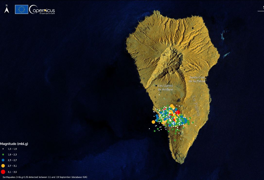
The following figure shows the hypocenters located in the last 24 hours (in red) and seismicity recorded since last Saturday September 11 (in grey). The yellow star shows the hypocenters of the earthquake recorded this morning at 11:16 p.m. Canary Time with magnitude of 4.2 and located at very superficial depth.
CONTEXT
In recent years, the Volcano of Old Summit has experienced 10 seismic swarms including the one that started this past Saturday (1 in 2017, 1 in the 2018 in 2020 in And 3 in 2021). The earthquakes of the latter swarm are more shallow than previous seismic swarm, where the depth ranged between 20 and 30 km. Without a doubt the current seismic swarm represents a significant change in the activity of the Volcano Old Summit and is related to a process of magmatic intrusion beneath La Palma Island.
According to Volcano Discovery “While the seismic swarm is still far from the levels of the first days of the crisis, which had started on 11 Sep, there is a noticeable trend of quakes becoming shallower. Combined with the ongoing deformation, the chances of a new volcanic eruption are gradually becoming larger: it seems that the pulse of new magma intruding underground, causing both the quakes and the uplift of the ground, has not yet stopped.”
Update 18th September 16.06 hrs
The seismic activity under la Cumbre Vieja has picked up again during the past 12 hours, after having decreased significantly during the previous day.
The largest quake was a magnitude 3.2 event at 03:26 (UTC) today, at shallow depth of 0.1 km, and was felt by the population. Up to today moment and since the beginning of the series, 5391 earthquakes have been detected, of which 1102 have been located.
The maximum accumulated vertical deformation is around 10 cm in the area close to the earthquake swarm and its distribution is still compatible with a center of pressure from a magma intrusion under the same area. These movements have been observed both with the island’s GNSS network and through InSAR data (Sentinel-1).
Sitrep 16th September 2021
LA PALMA “Earthquake Swarm” Increases threat of Volcanic Eruption
 MADRID, Sept 16 (Reuters) – Authorities on the Spanish Canary Island of La Palma have warned that a sudden increase in seismic activity could herald a volcanic eruption in the coming days or weeks.
Spain’s National Geographic Institute has detected 4,222 tremors in a so-called “earthquake swarm” in the Cumbre Vieja national park, around the Teneguia volcano in the far south of the island.
As the quakes intensified and moved closer to the surface, the Canary Island’s regional government on Tuesday put the island on a yellow alert for an eruption, the second of a four-level alert system.
It said on Thursday there was no clear evidence for an immediate eruption, though warned the situation could evolve rapidly.